

Ellie and I went on a mother-daughter hike today, something we are used to doing but that will come to an end now that Will is off for the summer and Ellie will be off to kindergarten in the fall. It’s crazy to think that the ‘just the two of us’ time that has filled so many of our days since she was born is over. (I think it’s really only just hitting me as I type that!) For such a momentous day, at least we had a momentous adventure!
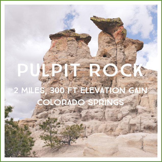
Pulpit Rock Park is a wonderfully accessible trail head conveniently a block away from the Trader Joes I am forever making up excuses to be nearby so I can pick up a few things. I didn’t do much research about the hike ahead of time, just noticed that no one seemed willing to say how long it was (which I understood once we were there). I had walked the first half a mile of the trail at a senior portrait photoshoot several years ago, so I remembered the well groomed trail and thought it would be a simple matter of following it to the top. Once actually hiking, though, I realized that the park has many different trails and forks and that following a single obvious path to the top might not happen. I asked several people on the way and once at the top about THE trail, and all said versions of “well, I follow this trail, but it disappears on you so you just have to keep going up and eventually you get to the top.” On the way down I thought for sure I had found The Way, but it disappeared on us and we ended up picking our way back to the trail we’d used on the way up. This afternoon I found this post that suggests that there is an obvious route if you go up the northeast face of the rock, (the other hikers we saw were all hiking toward the north side of the formation) so I might have to investigate that some day.
Pros: This trail is wonderfully accessible from the northern part of Colorado Springs, you have a great number of lunch options for afterward in the University Village shopping area across the street, and you can combine the hike with your Costco/Trader Joe errands. 😉 Pulpit Rock was very cool up close and the area surrounding it was pretty. We saw lots of birds and more flowers than I expected given that most aren’t blooming yet.
Cons: Because this is right next to I-25, you’ll never get away from the freeway noise. There is no map on site and the trails are not marked, so making your way with the various forks and disappearing trails could be stressful with young children. I found this map online, but it doesn’t seem particularly accurate to our experience–we followed that .05 trail down from the rock, but it didn’t connect in an obvious way to the others. (To be fair, we’ve had a lot of rain in the last few weeks so it’s possible that the trail had eroded away). I also assumed that the most obvious trail simply had to meet up with the car-tracks style path we’d followed on the way up, so on the way down we went east on the path. Instead of meeting up, though, it ended in a housing development. We crossed through the meadow and crossed the stream to head back on the best groomed walkway (which, unless you live in the subdivision it ends at, you would never actually walk on if go from the parking lot to the summit). The route Ellie and I took looked something like this:
.jpg)
Distance/Difficulty: Following the map, this could be a 2 mile hike. It could also be longer if you get lost. 😛 The beginning of the hike is gentle, with a steep push at the end to get to the top. Given the difficulty of finding and following the trails, I would give this a moderate difficulty rating (keeping a Family Hike grading scale in mind).
Directions:
From I-25 going south, take the Nevada Ave exit and take a left to go south on N Nevada Ave. At the first light take a left (confusingly onto N Nevada Ave) and go north past the Harley-Davidson dealership and Luisa Graff Jewelers. The trailhead parking lot is next to a power station. If you get to Woodmen Rd you’ve gone too far north.
Trail Teaching:
- Changing plantlife along the hike. There are also many birds to identify, particularly once you make it to the top.
- I didn’t look up the geology of Pulpit Rock before we left (I wanted to beat the late morning clouds), but this site has extensive information about the formation.
Photos:
.jpg)

There was plenty of evidence of our recent rain!
If you don’t take the first right fork and instead stay on the most northern trail, shortly after you cross this bridge there is a small fork to the right (south)–you’ll want to take this as after this the only way to get closer to Pulpit Rock is to cross the creek and possibly lose your wagon, provisions, and one child to the current.
Looking back at the northernmost East-West path:
Your mission:
Finding our own way after our trail disappeared I kept thinking of that scene in Tenth Kingdom where the daughter says “I didn’t know it was a race” and the dad says “I didn’t know that was a trail.”
Bird nests at the top:
Looking back along the ridgetop:
When your mom is usually a “stay on the trail” stickler and then this hike is all “well, I guess if we cut through here we should meet up with that trail over there” your smile gets pretty big:
Almost at the car!
Further Reading: The hike is popular among locals, so there are many summaries online including this one and the summary that suggested that there is an obvious route on the NE face of the rock formation.


Fran Cooper - Beautiful pictures. Thanks for the laughs thrown in there, too!!
Kelly Henry - And I’m bluebell the troll, Terrified throughout the 9 kingdoms!