
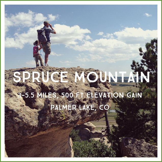
Spruce Mountain is another easy family favorite for those days when you want to go for a hike, but you don’t want to put any thought into it. Fitting in with the other hikes I’ve posted about this week, it’s another hike I feel comfortable doing with the kids by myself on a weekday. It’s a quick approximately 1 mile hike to the top of the Spruce Mountain mesa, followed by an approximately half mile to the loop portion of the trail. The loop adds another 2.3 miles to your hike, so if your kids are spent this is an easy spot to turn around. The additional 2 miles are flat, so this is a great hike for practicing adding mileage with your kids without adding any extra elevation.
Pros: I really like this hike for preschoolers. There’s lots of variety–bushes, trees, scrub brush, sun, shade, big rocks and sweeping 360 degree views, more closed in wooded sections…and did I mention the trains? Spruce Mountain runs parallel to the busy rail line that runs through Palmer Lake. A preschool boy can be very easily lifted in spirits by a big coal train sighting! And any hike near Palmer Lake is never complete without ice cream from the adorable Rock House ice cream parlor on your way home, so if the trains don’t work to propel little legs on those last miles, the promise of ice cream will!
.jpg)
Cons: This is a multi use trail so you’ll see plenty of bikers and horses (actually, move the horses to the pros column–another thing that helps distract toddlers on a 5 mile hike!). The southern section of the loop (“The Upper Loop”) is exposed and can be a very hot walk on a summer day–this is one you want to hit earlier versus later. For this reason I suggest going clockwise around the loop–get the longer, more exposed section over with first! The signs on the trail network can be confusing, so I recommend taking along this map.
Distance/Difficulty: About 5.5 miles if you include the loop around the top of the mesa, this is a great option for little hikers who have mastered Mt Cutler (my favorite recommendation for families beginning to hike), this stretches their distance abilities without adding any more difficulty in terms of elevation. Shortening the hike by dropping the loop makes it very comparable with Mt Cutler, though a little longer at about 3 miles.
Directions: If you are driving north on I-25 from Colorado Springs, take exit 163 for County Line Rd. After the railroad tracks turn right onto Spruce Mountain Rd. The well marked parking area is on the left in 3.5 miles. If you are coming from the north, take I-25S to the Larkspur exit. Travel south on Spruce Mountain Rd for 6 miles, the well marked parking lot will be on the right. The large parking lot has porta potties and a map. The trail is popular, but the only time we had trouble finding a parking spot was on a beautiful holiday afternoon.
Trail Teaching:
- Trains and railroad history in Colorado and its influence on city size/importance.
- Coal – odds are good that if you see a train, it will be loaded with coal.
- Palmer Lake is an interesting little town whose lake is completely dried up but used to be mined for ice. From the Tri Lakes Historic Society: “General William J. Palmer, a Medal of Honor recipient, came west after the Civil War to found the City of Colorado Springs & start the Denver & Rio Grande Railroad, a 3-ft. narrow gauge line, in 1871. He purchased the land known as the Monument Farms & Lake Property which was to become the Town of Palmer Lake. Palmer Lake was critical to the railroad because the steam trains chugged up to the Palmer-Divide summit and had to take on water to head down. The lake was the only natural water supply available on a year-round basis. Passenger trains would stop for 10 minutes to take on water, or you could get off for a day of picnicking, fishing, and boating or wildflower hikes for a fee of $1.50 roundtrip from Denver.”
- Mesas – Mesas get their name from Spanish explorers in the mid-1500s who thought the formations in the American southwest resembled tables (“mesa” in Spanish). “Butte” and “mesa” describe similar shapes, but mesas are larger than buttes. Mesas have a hard layer of rock at the top (“cap rock”)–often cooled lava–that resists the type erosion that is caused by the hard sudden rainstorms that occur in the American southwest. The top layer of igneous rock resists erosion, but the softer sedimentary rock around the igneous rock is eroded away. This creates the steep sides of the mesa–anything not directly under that tough igneous rock gets washed away in rainstorms. See if the kids can identify areas of igneous rock at the top of the mesa.
Photos:
.jpg)

Looking for trains:
The loop (The sheltered “lower loop” on the left, and the more exposed “upper loop” on the right):
We use Windy Point as a snack break spot. It’s at the just over halfway mark if you’re going on the loop, has great views, and is usually empty. Most people turn back at the Greenland Overlook, so the loop is usually quiet compared to the popular out-and-back section of the trail. (“I swear I’m a good mom” disclaimer: Given my almost paralyzing fear of heights, I’m positive this shot must be a lot less ‘near the edge’ than it looks!)
Further Reading: Given its proximity to Denver, there are several great posts about this hike from Denver area hikers. Check out Fun Colorado Hikes for many trail pictures, the official Douglas County website page for Spruce Mountain trail, and this pdf map.